
Tập tin:Exeter-20may44.jpg
Không có độ phân giải cao hơn.
Exeter-20may44.jpg (600×555 điểm ảnh, kích thước tập tin: 79 kB, kiểu MIME: image/jpeg)
Tập tin này từ Wikimedia Commons. Trang miêu tả nó ở đấy được sao chép dưới đây. Commons là kho lưu trữ tập tin phương tiện có giấy phép tự do. Bạn có thể tham gia. |
Miêu tả
| Miêu tả |
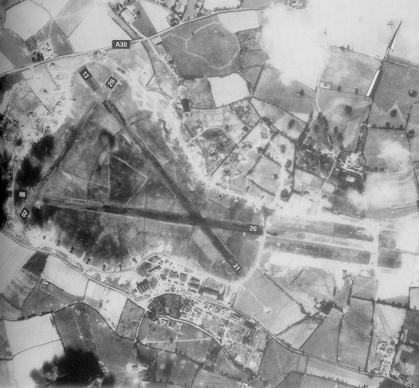
English: Exeter Airfield, England |
||||||
| Ngày | |||||||
| Nguồn gốc | Freeman, Roger A., Airfields Of The Ninth, Then And Now, 1993 (where the annotations are from) | ||||||
| Tác giả | Royal Ordinance Survey. | ||||||
| Giấy phép (Dùng lại tập tin) |
|

Nhật trình tải lên đầu tiên
Trang miêu tả gốc từng tồn tại ở đây. Tất cả các tên người dùng sau là tên người dùng tại en.wikipedia.
- 2007-05-15 23:39 Bwmoll3 600×555×8 (81388 bytes) Exeter Airfield, England, 20 May 1944 Source: Royal Ordinance Survey. Crown Copyright expired 50 years after photograph taken in 1994. Annotations on photo from Freeman, Roger A., Airfields Of The Ninth, Then And Now, 1993
Lịch sử tập tin
Nhấn vào ngày/giờ để xem nội dung tập tin tại thời điểm đó.
| Ngày/giờ | Hình xem trước | Kích cỡ | Thành viên | Miêu tả | |
|---|---|---|---|---|---|
| hiện tại | 10:29, ngày 21 tháng 5 năm 2008 | | 600×555 (79 kB) | Aps1 | {{Information |Description={{en|Exeter Airfield, England, 20 May 1944 Source: Royal Ordinance Survey. Crown Copyright expired 50 years after photograph taken in 1994. Annotations on photo from Freeman, Roger A., Airfields Of The Ninth, Then And Now, 1993 |
Trang sử dụng tập tin
Có 1 trang tại Wikipedia tiếng Việt có liên kết đến tập tin (không hiển thị trang ở các dự án khác):
Sử dụng tập tin toàn cục
Những wiki sau đang sử dụng tập tin này:
- Trang sử dụng tại bg.wikipedia.org
- Trang sử dụng tại ca.wikipedia.org
- Trang sử dụng tại en.wikipedia.org
- Trang sử dụng tại ru.wikipedia.org
- Trang sử dụng tại si.wikipedia.org
- Trang sử dụng tại uk.wikipedia.org