
Tập tin:Tahiti, French Polynesia - NASA Earth Observatory.jpg
Tahiti,_French_Polynesia_-_NASA_Earth_Observatory.jpg (720×480 điểm ảnh, kích thước tập tin: 137 kB, kiểu MIME: image/jpeg)
Tập tin này từ Wikimedia Commons. Trang miêu tả nó ở đấy được sao chép dưới đây. Commons là kho lưu trữ tập tin phương tiện có giấy phép tự do. Bạn có thể tham gia. |
Miêu tả
| Miêu tả |
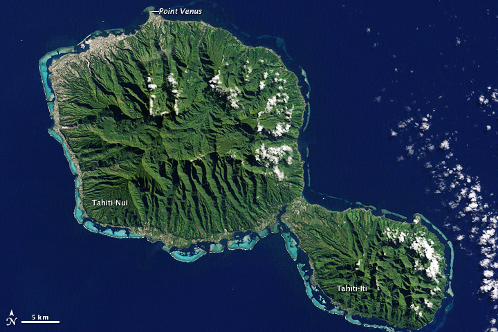
To download the full resolution and other files go to: earthobservatory.nasa.gov/IOTD/view.php?id=78218&src=... In August 1768, Captain James Cook, naturalist Joseph Banks, and a shipload of sailors set sail from England to Tahiti to observe the Transit of Venus. Camped out on Point Venus, they witnessed the event on June 3, 1769. Cook sketched the transit, but Banks had surprisingly little to say about it. Perhaps he was distracted by the wonders of the island itself. The Enhanced Thematic Mapper Plus on the Landsat 7 satellite captured this natural-color image of Tahiti on July 11, 2001. This island is part of a volcanic chain formed by the northwestward movement of the Pacific Plate over a fixed hotspot. Tahiti consists of two old volcanoes—Tahiti-Nui in the northwest and Tahiti-Iti in the southeast—linked by an isthmus. Through studies of its rock layers, geologists have figured out the likely history of Tahiti-Nui. Today it is roughly round, and it was roughly round when it first formed as a volcanic shield between 1.4 million and 870,000 years ago. But between then and now, it had a different contour. Both the northern and southern flanks of Tahiti-Nui collapsed sometime around 860,000 years ago, gouging massive arcs out of the island’s perimeter. Soon after the northern flank collapse, a second shield volcano began forming. Volcanic material on the northern side of Tahiti-Nui eventually overtopped the original volcanic structure and started filling in the southern depression. Although Tahiti-Nui now has a fairly symmetrical contour, it has an asymmetrical three-dimensional shape. Mountains are taller on the northern half of the island. Yet something else besides volcanic activity has shaped Tahiti: rain. Heavy tropical rains have carved deep valleys, some with nearly vertical walls up to 1,000 meters (3,000 feet) tall. The angled sunlight in this image brightens some slopes, while leaving others in shadow. Tahiti’s sharp relief has complicated the geological surveys because they cause so much erosion. But the same rains have also promoted the growth of the lush plants that carpet both Tahiti-Nui and Tahiti-Iti. Though the Transit of Venus was the stated objective of the British expedition, Banks was likely more interested in Tahiti’s plants. Specimens he collected from Tahiti, New Zealand, South America, Australia, and Java accounted for roughly 1,300 new species, and his famed collected is now stored at the Natural History Museum in London. Complementing the rich life on land is marine life around Tahiti’s perimeter. Coral reefs fringe the island, and the reefs are thickest on the southern and western sides. Reefs frequently form along the submerged slopes of volcanic islands. NASA Earth Observatory image by Jesse Allen and Robert Simmon, using Landsat data from the U.S. Geological Survey. Caption by Michon Scott. The Earth Observatory's mission is to share with the public the images, stories, and discoveries about climate and the environment that emerge from NASA research, including its satellite missions, in-the-field research, and climate models. Like us on Facebook Follow us on Twitter Add us to your circles on Google+ |
| Ngày | |
| Nguồn gốc | Tahiti, French Polynesia |
| Tác giả | NASA's Earth Observatory |
| Vị trí máy chụp hình | | Xem hình này và các hình ảnh lân cận trên: OpenStreetMap |
|---|
Giấy phép
- Bạn được phép:
- chia sẻ – sao chép, phân phối và chuyển giao tác phẩm
- pha trộn – để chuyển thể tác phẩm
- Theo các điều kiện sau:
- ghi công – Bạn phải ghi lại tác giả và nguồn, liên kết đến giấy phép, và các thay đổi đã được thực hiện, nếu có. Bạn có thể làm các điều trên bằng bất kỳ cách hợp lý nào, miễn sao không ám chỉ rằng người cho giấy phép ủng hộ bạn hay việc sử dụng của bạn.
| Hình này, ban đầu được tải lên tại Flickr bởi NASA Earth Observatory vào https://www.flickr.com/photos/68824346@N02/7180520297. Tập tin đã được FlickreviewR kiểm tra vào 2 tháng 7 năm 2012 và xác nhận rằng nó tuân theo các điều khoản của cc-by-2.0. |
Lịch sử tập tin
Nhấn vào ngày/giờ để xem nội dung tập tin tại thời điểm đó.
| Ngày/giờ | Hình xem trước | Kích cỡ | Thành viên | Miêu tả | |
|---|---|---|---|---|---|
| hiện tại | 17:01, ngày 2 tháng 7 năm 2012 | | 720×480 (137 kB) | Dzlinker | == {{int:filedesc}} == {{Information |Description=To download the full resolution and other files go to: [http://earthobservatory.nasa.gov/IOTD/view.php?id=78218&src=flickr earthobservatory.nasa.gov/IOTD/view.php?id=78218&src=...] In August 1768, Capt... |
Trang sử dụng tập tin
Sử dụng tập tin toàn cục
Những wiki sau đang sử dụng tập tin này:
- Trang sử dụng tại af.wikipedia.org
- Trang sử dụng tại ast.wikipedia.org
- Trang sử dụng tại cs.wikipedia.org
- Trang sử dụng tại el.wikipedia.org
- Trang sử dụng tại en.wikipedia.org
- Trang sử dụng tại et.wikipedia.org
- Trang sử dụng tại fa.wikipedia.org
- Trang sử dụng tại fo.wikipedia.org
- Trang sử dụng tại he.wikipedia.org
- Trang sử dụng tại mk.wikipedia.org
- Trang sử dụng tại nl.wikipedia.org
- Trang sử dụng tại pl.wikipedia.org
- Trang sử dụng tại pl.wiktionary.org
- Trang sử dụng tại ru.wikipedia.org
- Trang sử dụng tại sk.wikipedia.org
- Trang sử dụng tại sl.wikipedia.org
- Trang sử dụng tại zh-min-nan.wikipedia.org