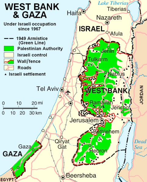
Tập tin:West Bank & Gaza Map 2007 (Settlements).png

Kích thước hình xem trước: 482×599 điểm ảnh. Độ phân giải khác: 193×240 điểm ảnh | 386×480 điểm ảnh | 780×970 điểm ảnh.
Tập tin gốc (780×970 điểm ảnh, kích thước tập tin: 86 kB, kiểu MIME: image/png)
Lịch sử tập tin
Nhấn vào ngày/giờ để xem nội dung tập tin tại thời điểm đó.
| Ngày/giờ | Hình xem trước | Kích cỡ | Thành viên | Miêu tả | |
|---|---|---|---|---|---|
| hiện tại | 22:55, ngày 29 tháng 10 năm 2013 |  | 780×970 (86 kB) | Scott | Correct capitalization in legend. |
| 22:54, ngày 29 tháng 10 năm 2013 |  | 780×970 (86 kB) | Scott | Correct capitalization in legend. | |
| 06:21, ngày 12 tháng 1 năm 2009 |  | 780×970 (105 kB) | HowardMorland | Replace .gif file with identical .png file <!--{{ImageUpload|basic}}--> |
Trang sử dụng tập tin
Có 1 trang tại Wikipedia tiếng Việt có liên kết đến tập tin (không hiển thị trang ở các dự án khác):
Sử dụng tập tin toàn cục
Những wiki sau đang sử dụng tập tin này:
- Trang sử dụng tại am.wikipedia.org
- Trang sử dụng tại ar.wikipedia.org
- Trang sử dụng tại ast.wikipedia.org
- Trang sử dụng tại azb.wikipedia.org
- Trang sử dụng tại bg.wikipedia.org
- Trang sử dụng tại ca.wikipedia.org
- Trang sử dụng tại ckb.wikipedia.org
- Trang sử dụng tại cs.wikipedia.org
- Trang sử dụng tại cy.wikipedia.org
- Trang sử dụng tại da.wikipedia.org
- Trang sử dụng tại de.wikipedia.org
- Trang sử dụng tại de.wikinews.org
- Trang sử dụng tại de.wikivoyage.org
- Trang sử dụng tại en.wikipedia.org
- Talk:List of ongoing armed conflicts
- User:Timeshifter/Userboxes
- User:Gimmetrow/test
- User:Gimmetrow/test2
- User:Keizers
- Talk:Jerusalem/Archive 15
- Talk:Palestinian Authority/Archive 2
- Wikipedia:Top 25 Report/July 13 to 19, 2014
- Wikipedia:Top 25 Report/July 20 to 26, 2014
- Wikipedia:Top 25 Report/July 27 to August 2, 2014
- Talk:State of Palestine/Archive 12
- User:Timeshifter/Userboxes/Palestine: Peace Not Apartheid. By Jimmy Carter
- User:TheSouthernIrishman
- User:Dare2Leap/info
- User:Timeshifter/Archive 2
- Wikipedia talk:WikiProject Israel Palestine Collaboration/Archive 9
- Trang sử dụng tại en.wikinews.org
- Trang sử dụng tại eo.wikipedia.org
- Trang sử dụng tại es.wikipedia.org
- Trang sử dụng tại eu.wikipedia.org
- Trang sử dụng tại fa.wikipedia.org
- Trang sử dụng tại fi.wikipedia.org
- Trang sử dụng tại fo.wikipedia.org
- Trang sử dụng tại fr.wikipedia.org
Xem thêm các trang toàn cục sử dụng tập tin này.
